The subduction zone structure is inferred from regional surface and subsurface studies, including interpreted seismic profiles, gravity and tomography data, receiver function analysis, and earthquake focal mechanisms. The information included in this layer is thus based on geological and geophysical data that characterizes the subduction zone in terms of geometry (depth, dip direction) and behavior (convergence azimuth and rate) parameters. Minimum and maximum values of each parameter are provided to capture their range of variability.
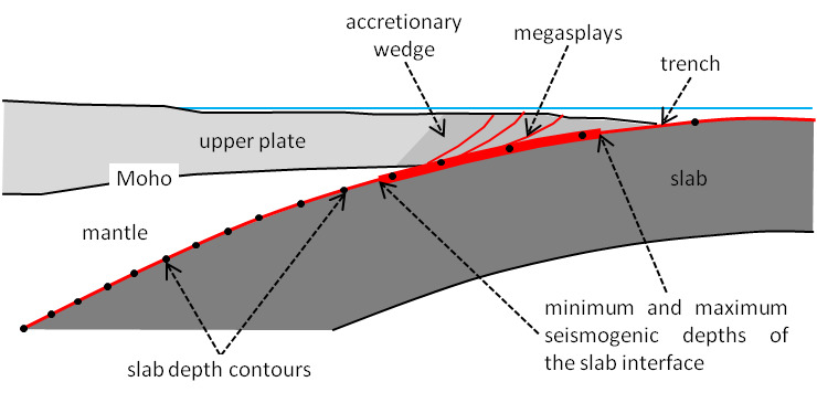
As recalled above, the tectonic processes acting in a subduction zone can generate several types of earthquakes. However, the largest earthquakes are commonly expected to occur at the slab interface. We thus identify the main seismogenic source with the slab interface and provide its extent in terms of its minimum and maximum depth limits. Subduction zones are not assumed to be capable of a specific-size earthquake or specific recurrence behavior, but their seismic potential can be assessed in various ways, including estimates from their tectonic or geodetic moment rate or the analysis of earthquake catalogs.
Similarly to the other categories of DISS sources, each Subduction Source is identified by the code CCSD###, where:
- CC is the two-letter ISO 3166-1 code for names of officially recognized countries;
- SD identifies specifically the Subduction Source;
- ### is an ordinal between 1 and 999 (including leading zeroes).
References
Bilek, S. L., and T. Lay (1999). Rigidity variations with depth along interplate megathrust faults in subduction zones. Nature, 400, 6743, 443-446, https://doi.org/10.1038/22739
Satake, K., and Y. Tanioka (1999). Sources of Tsunami and Tsunamigenic Earthquakes in Subduction Zones. Pure Appl. Geophys., 154, 3, 467-483, https://doi.org/10.1007/s000240050240
Strasser, F. O., M. C. Arango, and J. J. Bommer (2010). Scaling of the Source Dimensions of Interface and Intraslab Subduction-zone Earthquakes with Moment Magnitude. Seismol. Res. Lett., 81, 6, 941-950, https://doi.org/10.1785/gssrl.81.6.941